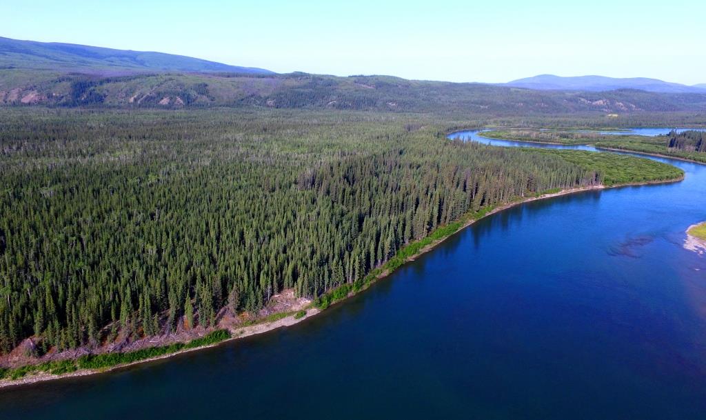
(Gord Allison photo)
Introduction
Christmas Day of 1899 saw one of the most cold-hearted cases of pre-meditated murder in Yukon history. Three good men named Frederick Clayson, Linn Relfe and Lawrence Olsen were ambushed and killed along the Yukon River winter trail near Minto simply for the valuables they might have been carrying. Clayson, doing business in Dawson City and Relfe, who was working there, were on their way from Dawson City to their respective homes in Skagway and Seattle. Olsen was a telegraph lineman based at the Five Fingers station.
A fourth man known as Thomas Graves, believed to be an accomplice in the murders, may also have been killed, but no body identified as his was ever found. The final death in this case occurred when George O’Brien was hung for murder in Dawson City in 1901.
The disappearance of Clayson, Relfe and Olsen, particularly during the months until their bodies were found, created headlines across North America. Newspapers continually pressed the Northwest Mounted Police (NWMP) for information, and when none was forthcoming they were not hesitant to speculate on the case.
In the end, it was an example of where “the murderer was caught before the case was solved”. However, solving it may not have happened if not for a unique combination of factors:
- new communications technology, in this case the Yukon Telegraph line;
- a Christmas dinner invitation;
- horses and a sleigh falling through ice; and
- two dogs, a big yellow one and a husky.
I hadn’t initially intended to write a lengthy story on this murder case because a book has been written about it. In 1982, Murray J. Malcolm published Murder in the Yukon: The Case Against George O’Brien, based on his study of the Library and Archives Canada files on this event. This book and the files give a general sense of where this tragic event occurred, but not enough that an interested reader can fully understand the context of the story. My main interest in it was in determining and documenting the places associated with the murder and the site itself.
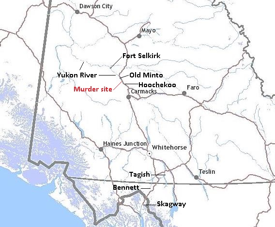
The NWMP took detailed measurements at the crime scene and of the trails involved and made very good hand-drawn maps of the murder area. However, these maps cannot be definitively matched up with the landscape today. Furthermore, places on the maps that could be used for locational context, Minto to the north and Hoochekoo NWMP post to the south, are no longer generally known or mapped. Also, the Minto labelled on the NWMP map is now known as Old Minto, located two miles south and on the opposite side of the Yukon River from present-day Minto. The Hoochekoo NWMP post site is known, but does not appear on any current maps or in general sources of information.
Fortunately, the NWMP took a number of photos of the murder site and related spots that allow their locations to be determined with more certainty. Ron Chambers and I went to the area and matched up these photos with the views on the land to pinpoint the locations. Ron has a personal link to this case because his grandfather Thomas Dickson was the Mountie who arrested the murderer George O’Brien at Tagish on January 7, 1900.
An additional interest to me about this murder case is that it involves a number of related Yukon history themes such as the Yukon River winter trail, roadhouses, NWMP posts and the telegraph line. Reading about this case also gives a snapshot of life and travel in the winter on the Yukon River at the time of the Klondike Gold Rush. An awareness of these topics allows a fuller appreciation of the murder story, so this article touches on them to provide additional context.
All reporting and mapping of this murder case used the imperial system of measurement rather than metric, so the imperial units will be used here as well. It should be noted that all distances are in ‘river miles’ rather than ‘as the crow flies’. Distances between locations on the Yukon River vary depending on the source, so for consistency I have used Mike Rourke’s Yukon River (Marsh Lake to Dawson City) guidebook.
In the era when rivers were the primary routes of travel, people went ‘down’ to Dawson or ‘up’ to Whitehorse based on the flow of the Yukon River. Now in the era of highways we say the opposite, based on Dawson being north of Whitehorse. To avoid confusion, ‘north’ and ‘south’ are used here rather than ‘upriver’ and ‘downriver’ as was used most commonly when this murder event occurred. In the area of the murder, the Yukon River valley trends northwest-southeast, so ‘north’ and ‘south’ are used in their broader sense.
The Historical and Geographical Setting
The Yukon River Winter Trail
Riverboat travel to and from Dawson City during the Klondike Gold Rush of the late 1890’s and afterwards is very well known and documented. However, this mode of transport could only take place for less than half the year. After the riverboats made their final trips in late fall before freeze-up, people travelling to or from the Klondike during the winter months had only one option: the Yukon River winter trail (hereafter referred to as the ‘river trail’). In the fall of 1902, a second and more expedient option became available when the Whitehorse-Dawson Overland Trail was completed and travellers could ride in relative comfort in horse-drawn stages.
Once the river was frozen enough to be safe for walking, the river trail soon became established for travel from Dawson to Skagway and vice-versa. There was enough traffic that it became wide and well-packed, and a variety of modes of travel were used, including walking, bicycling, dogsleds and a few horse-drawn sleighs.
It was along this trail to the ‘outside’ that Frederick Clayson, Linn Relfe, George O’Brien and Thomas Graves set out from Dawson City in late 1899. Farther south, the telegraph lineman Lawrence Olsen was using the trail regularly to carry out his work.
Roadhouses and Stopping Places
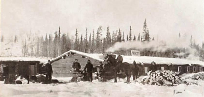
Once the Klondike Gold Rush was in full swing, a number of establishments sprang up along the trail to accommodate winter travellers. Some were substantial log roadhouses while others were more primitive ‘stopping places’ that usually consisted of a log frame covered by a canvas tent. According to the NWMP, by the fall of 1898 there were about 35 roadhouses and stopping places, averaging 14 miles between them. This spacing was close enough that even in mid-winter with minimal hours of daylight for travel, people that stayed at these places rather than camp out did not have to carry sleeping gear and food.
In the Minto area where the murders occurred, some of the activity was centered on the roadhouse belonging to John and Agnes Fussell. Located on the opposite (west) side of the river two miles south of present-day Minto, it had just opened in the late fall of 1899. The murdered men spent Christmas Eve, the last night of their lives, at this roadhouse.

(Library & Archives Canada, #4942083)
Northwest Mounted Police (NWMP) Posts
With the Klondike Gold Rush came the need to establish a police presence along the travelled routes. By the fall of 1898 a series of NWMP posts had been built along the Yukon River to monitor people and their activities and to assist in a variety of functions.
Posts with a connection to the murders were located at Five Fingers (about a mile and a half downstream from the rapids of the same name), Hoochekoo 16 miles north of Five Fingers, and Fort Selkirk 39 miles north of Hoochekoo. Constable (soon to be Corporal) Patrick Ryan and Constable Alick Pennycuick, the two NWMP members most integral in the murder case, were posted at Hoochekoo and Fort Selkirk, respectively.

(Library & Archives Canada, #PA-146779)
These posts generally consisted of a 20’x30’ detachment/barracks building and a 16’x22’ storehouse, as well as a latrine and often a stable. Staffing of the posts generally depended on how busy and centrally located they were. At the time of the murders, Five Fingers post had one Seargeant and three Constables, Hoochekoo had one Constable and a Special Constable (usually referred to as a dog driver), and Fort Selkirk had two Constables.
The Yukon Telegraph
A significant factor in the murder case was that the Yukon Telegraph project to bring telegraph communications to Dawson City had just been completed in late September 1899. It enabled messages to be sent within the Yukon and improved the Yukon’s connection with the outside world. Messages to the ‘outside’ that previously took a month by mail, and often longer in the winter, were received within a week. Two years later, that time would be reduced to 10 minutes when completion of an all-Canadian telegraph line linked the Yukon with southern Canada.
The project started at Bennett, at the south end of Lake Bennett, the beginning of the waterway travel corridor to the Klondike region. In the summer of 1899, Bennett was also the interim terminus of the White Pass & Yukon Route railway and an accompanying telegraph line from Skagway. The Yukon Telegraph linked in to that line and then proceeded northwards along the Yukon’s southern lakes and down the Yukon River valley to Dawson City, primarily following the west side of the river. The line consisted of trees and poles spaced on average 225 feet apart, with insulators attached near the top of them and the telegraph wire strung in between about 12 feet above the ground.
Telegraph stations were established along the line, often in association with NWMP posts. In 1899 there were 12 stations built in the Yukon, including at Five Fingers (at the same location as the NWMP post) and Fort Selkirk. Some stations were relatively spacious, but others were one-room cabins that had to accommodate two people and the telegraph equipment. The staff consisted of a telegraph operator and a lineman, the latter for maintaining and repairing the line to minimize service disruptions. Because the telegraph service was so important to the NWMP in their functions, the linemen were often assisted in their duties by police members.
The telegraph line was constructed through the Minto area in latter August 1899 and completed at Dawson City on September 28. Three months later the investigation into the disappearance of Frederick Clayson, Linn Relfe and Lawrence Olsen was beginning, and had the telegraph line not been in place at that time, there is a good chance that the murderer George O’Brien would have gotten away.

(Yukon Lands Viewer)
1899 Freeze-up – Scows, Caches and the Pork Trail
Freeze-up of the Yukon River had come suddenly in the late fall of 1899 and a number of scows carrying provisions to Dawson City became trapped in the ice. The freight had been unloaded and cached on shore before the scows were crushed in the ice jams, and the goods were gradually being transported by horse-drawn sleighs to Dawson. The NWMP tried to keep an eye on these caches during their patrols, but this wasn’t sufficient to keep them from being pilfered and the goods sold to whatever people or establishments would buy them. Complaints began coming in to the NWMP about thefts from these caches along the river.
One cache that played a role in the murders was called McKay’s because it contained goods being shipped to McKay Brothers in Dawson. It was located on the west side of the river about five miles south of Old Minto, and the murders took place not far from it.
A challenge for getting sleighs loaded with goods over the river trail were areas of rough jumble ice, and one stretch of this was south of Old Minto. In December 1899 a man named William Powell and his crew, who were freighting pork over the trail to Dawson with two teams of horses, cut out a three-mile trail through the bush on the west side of the river to get around the bad ice. Although this trail was only used once for this purpose, it became known as the Pork Trail in the murder saga to distinguish it from the river trail. McKay’s cache was located close to where the north end of the Pork Trail rejoined the river trail.
The Pork Trail ended up playing a role in the murders because it provided O’Brien and Graves with an opportunity to establish a hidden campsite, a lookout for potential victims, and a site for carrying out the murders. They could do all this preparation work out of sight from the river trail where people were travelling.
Next: Part 2 (The Murders)
the murderer had to have been a paddy