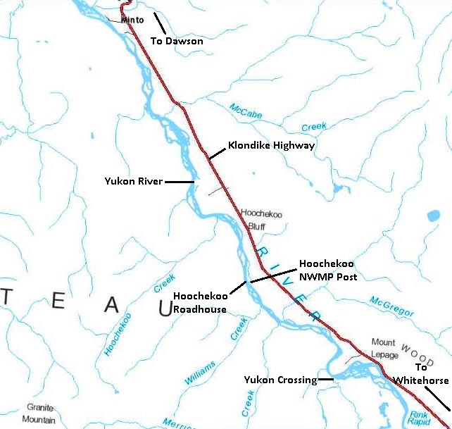
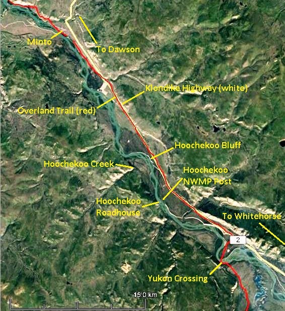
At kilometer 411 of the North Klondike Highway, about 20 kilometers south of Minto, the Yukon River is half a kilometer to the west, but you cannot see it. Along the near side of the river at that location is an imposing rock bluff that you also cannot see from the highway. This is Hoochekoo Bluff, and about two kilometers from it down the river (north) and on the opposite side of the river is Hoochekoo Creek.

(Yukon Lands Viewer)
Hoochekoo is the official place name for the bluff and the creek, but there are a number of different spellings of the name in various sources. It was a more widely known name at the time of the Klondike gold rush and for some years following than it is now. It was the location of a Northwest Mounted Police (NWMP) post and a roadhouse, established within half a kilometer of each other about five kilometers upriver (south) of Hoochekoo Bluff. The bluff itself was also a landmark for riverboat pilots during the years until the mid-1950s that they were operating on the Yukon River.

(Gord Allison photo)
Some places along the Yukon River that were regular stops for the riverboats and winter trail travellers persisted for several decades after the gold rush. However, Hoochekoo was not one of these places, with both the roadhouse and the NWMP post there being relatively short-lived.
The Hoochekoo name and the stories associated with it have faded with time, but evidence of both of these establishments still exists on the land as proof of their location and place in Yukon history.
In the following discussion, miles will be used rather than kilometers because that is what was in use at the time.
Yukon River Winter Trail
The Yukon River system was the primary transportation corridor to and from the Klondike during the gold rush and years following. The Chilkoot Trail from Skagway to Bennett was also part of the Klondike route until completion of the White Pass & Yukon Route railway from Skagway to Whitehorse in 1900 simplified transportation in that region. However, everywhere north of Whitehorse still remained reliant on river travel year round, other than the fall freeze-up and spring break-up periods when travel was unsafe.
During the winter when the riverboats were not running, a trail along the river (with a few cut-offs over land) became the main travel route. The river trail was established when the ice was safe and it fairly quickly became used by those who needed to travel. The trail soon had enough traffic on it that it was well-packed and wide enough to accommodate various modes of transport, including walking, bicycling, dogsleds and horse-drawn sleighs.
The information sources vary somewhat in the stated distance along the river between Whitehorse and Dawson, but it was on the order of 450 miles. It was another 100 miles or so via the water route to Bennett, at the start of the Chilkoot Trail to the coast.
The Yukon River winter trail saw considerable two-way traffic and activity during the four years following the large influx of people into the Klondike in 1898. This brought on the establishment of roadhouses to serve travellers, some by entrepreneurs and others in partnership with the mail delivery companies. The amount of traffic also necessitated the establishment of Northwest Mounted Police posts at intervals along the river.
The number of roadhouses along the Yukon River between Whitehorse and Dawson varied year to year that the river winter trail was in use. The total number established during these years was upwards of 80, according to the various sources that documented them. The Northwest Mounted Police reported there to be 35 operating by the fall of 1898, which averaged 13 miles apart. A list compiled by the photographer Jeremiah Doody in early 1901 contained 50 places, although it is not known how many of these were actually operating.

(Whitehorse Star, 6 February 1901)
Some roadhouses were substantial log structures while others were fairly primitive, some being referred to by name only as ‘tents’, such as Halfway Tent and Seven-Mile Tent. Some locations were termed ‘stopping places’ rather than roadhouses, and many may have only lasted a short time, perhaps as a way for someone to make some money along the way to Dawson. At least one trail diary gives the impression that some of these places were abandoned, but were still suitable for use as shelters.
For most of the winter trail roadhouses, particularly those not near the small settlements or centers of activity, there is very little information about their location, type of establishment, and who established and operated them. The only information given in the sources is the mileages between them, which often differs among the sources. These mileages allow an approximation of location, and a few have photographic evidence contain some landscape that may be able to be matched up on the ground to determine the site.
In addition to roadhouses, there were 17 NWMP posts established during this period along the river between Whitehorse and Dawson, 14 of them in the big gold rush year of 1898. Some of these were seasonal, where the members at a post that was needed for the winter trail traffic would be shifted to a post that served the summer riverboat traffic. The NWMP post locations are more identifiable on the land than most roadhouses because of the greater amount of information associated with them, including legal survey plans in some cases.
In 1899 one part of the winter route deviated from the river when a 94-mile long trail was built over land. It went from the north end of Lake Laberge northwesterly toward what is now Twin Lakes on the Klondike Highway, then northerly toward Carmacks and terminating near Yukon Crossing. This trail became known as the “CDC Cut-Off” for the Canadian Development Company, which had the mail delivery contract at the time.
The new trail cut nearly 80 miles off of the Yukon River trail, making the distance between Whitehorse and Dawson now around 370 miles. Equally importantly, it avoided travel on dangerous sections of the river, namely Five Finger Rapids, Rink Rapids and the Thirty Mile (Yukon River from Lower Laberge to Hootalinqua at mouth of the Teslin River).
This new cut-off trail necessitated the establishment of two new NWMP posts and at least four roadhouses to serve the traffic using it. It also resulted in staffing of the Big Salmon and Little Salmon NWMP posts in the summer only (when there was river traffic) and then their eventual closure. Most of the roadhouses along the Yukon River between Lake Laberge and Yukon Crossing were also abandoned because they were no longer on the winter trail.
The pattern of roadhouses and NWMP posts along the river winter trail and the CDC Cut-Off lasted for four winter seasons following the large influx of people into the Yukon in 1898. A big change to this pattern came in the fall of 1902, when the Whitehorse-Dawson Overland Trail was built and became the main winter travel route. This new road avoided travel on ice except at river crossings and was shorter than the winding winter trail, making the new Whitehorse to Dawson distance about 330 miles. It could accommodate horse-drawn sleighs and wagons, allowing travellers to ride in relative comfort.

(Google Earth)
New roadhouses and NWMP posts were built along the Overland Trail to serve travellers on the new route. However, for many of the roadhouses and several NWMP posts on the river trail, they were now off the beaten track and it spelled the end for them. This was the case for the Hoochekoo roadhouse and NWMP post.
Hoochekoo NWMP Post

(Dawson Daily News, 21 July 1909)
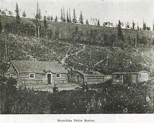
The location for a NWMP post at Hoochekoo (spelled both Hootchikoo and Hutshiku by the NWMP) about eight miles downriver (north) of Yukon Crossing was selected on the advice of Commissioner Ogilvie in 1898. On September 18 of that year the final site and a 40-acre reserve were picked out and a constable and three civilians left there to build the post. It consisted of a 22’x32’ detachment/barracks building, a 16’x20’ storehouse, a 15’x20’ stable, as well as a dog house and latrine, all built with logs from the site.

(Library & Archives Canada, RG18M, File 80103-59)
Staffing at the Hoochekoo post was minimal, with a constable and a special constable, the latter often in a role referred to as the ‘dog driver’. In late 1899 and early 1900 the post played a pivotal role in solving the murders of Frederick Clayson, Linn Relfe and Lawrence Olsen and bringing the killer to justice. This tragic event occurred about 10 miles downriver (north) from the post on Christmas Day of 1899. The first person to suspect foul play was Constable Patrick Ryan, in charge of the Hoochekoo post, when telegraph lineman Lawrence Olsen failed to show up at the post for Ryan’s invitation to Christmas dinner. Ryan initiated the first search for the men and found the first evidence related to the crimes. (a link to the Christmas Day Murder story is at end of this article).
In August 1900 the 40-acre parcel of land selected as a reserve for the Hoochekoo post was surveyed out. These large reserves were commonly granted to the NWMP to ensure a supply of timber, an important consideration along the Yukon River where there was competition for wood as fuel for steamboats.

(Canada Lands Survey Records #8894)
In 1902 the construction of the Overland Trail bypassed the Hoochekoo post by about a mile to the east. The NWMP viewed the post to then be in an “undesirable location” and closed it temporarily, distributing the staff and provisions to the Minto and Fort Selkirk detachments. By the next year, closure of the Hoochekoo post became permanent and its buildings were taken down and used in the construction of a new post at Yukon Crossing, eight miles south at the Overland Trail crossing of the Yukon River.
The survey plan for the Hoochekoo NWMP post provided an indication of its location, so in August 2016 Ron Chambers and I went there to look for signs of it. It was not in an obvious spot, located about 80 meters back in the bush from a riverbank that was not very inviting. After some hunting around, evidence of the post was found at the base of a bench rising up on the east side.

(Gord Allison photo)
The main evidence of the post was in the form of a large excavation that the detachment/barracks building appears to have been built over. This would have been a cellar for keeping provisions cool in the summer and from freezing in the winter. The only remaining structure at the site was a small log building that appears to be the house for dogs, of which several were kept at the post.

(Gord Allison photo)

(Gord Allison photo)
It was evident that after the site for the post was selected in mid-September of 1898, considerable labor was involved in excavating the cellar for the barracks, cutting and hauling logs to the building site, and constructing the buildings, all before winter set in.

(Library & Archives Canada, RG18, Vol. 254, File 318)
Hoochekoo Roadhouse
A roadhouse in the Hoochekoo area is mentioned in at least two sources. Doody’s 1901 list had it located 14 miles north of Yukon Crossing (called Mackay’s on his list) and 10 miles south of Old Minto, although the correct distances are closer to eight and 15 miles, respectively. A diary kept by Myrtle Ryan Bunger during a trip in early 1900 along the river winter trail mentions staying at McMillan’s roadhouse at ‘Hootchcoo’, with no other information given. I have not determined who McMillan might have been.
Based on my research, it seems that very few of the short-lived roadhouses along the Yukon River winter trail have had their locations determined on the ground by the finding of remnants. The only information about location are the sources’ recording of the mileages from the next roadhouse in each direction. In the case of the Hoochekoo roadhouse, its name is also an indicator of location, but it is misleading because it was actually located a few miles up the river (south) of Hoochekoo Bluff and Creek.
The Hoochekoo roadhouse, however, has the rare distinction of being mapped, which I found in the course of researching another topic. Files on the O’Brien murder case are held at Library & Archives Canada in Ottawa and include maps that had been drawn by Constable Alick Pennycuick, one of the primary investigators in the case, in preparation for O’Brien’s murder trial. Pennycuick’s overview map covered 16 miles along the Yukon River from Hoochekoo to Old Minto.

(Library & Archives Canada, RG18, Vol. 254, File 318)
Near the left edge of this map was a label for “Hoo-che-koo Roadhouse” on the north end of an island. There are a number of islands in the general Hoochekoo area, but another helpful label on the map showed that the roadhouse was located directly across from the NWMP post.

(Library & Archives Canada, RG18, Vol. 254, File 318)
There was an additional notation of interest in one of the O’Brien case files. On a sheet listing expenses incurred by the NWMP in connection with the case was an entry in February 1900 for a J. Lusk of ‘Hootchiku’. It was for supplying hay when O’Brien and his horses were brought from Tagish, where he was arrested, back to Dawson. There was also a charge for providing meals to James Powell, a witness in the case. I have not yet been able to find anything out about J. Lusk in relation to the roadhouse.
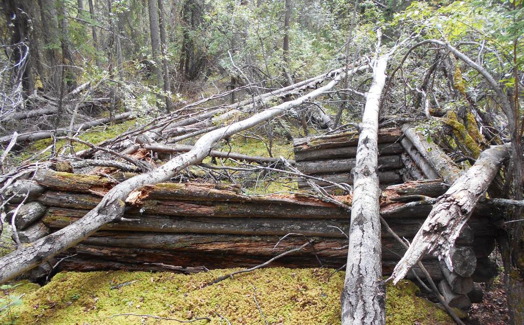
In July 2018 Ron Chambers and I stopped at this island to see if there was any evidence remaining of the roadhouse. A short walk up onto the downriver end of the island brought us to a pile of old cut and notched logs that had obviously been a cabin or similar structure. Over the years river ice and high water had torn the structure apart and pushed the logs up against a large spruce tree.

(Gord Allison photo)
The fairly thick ground growth in the vicinity made it difficult to look for the original location of the roadhouse or for other evidence that might have been part of the structure or contained within it. What we were able to determine conclusively is that this structure is located in the exact place that the Hoochekoo Roadhouse is shown on Pennycuick’s map. We were therefore confident that we found the roadhouse that was likely abandoned by 1902 and has since been ravaged by the forces of Yukon River ice and floods.
Finding and documenting evidence of history that still remain on the landscape helps to tell the small stories that make up the overall story of the Yukon. The Hoochekoo NWMP post and roadhouse are examples of it.

(Gord Allison photo)
Link to the related O’Brien murder story: The Christmas Day Murders – part 1
Updated 13 February 2022.
I am documenting my great-grandfather’s Yukon diary from the spring of 1901. You mentioned you weren’t sure which roadhouses were actually operating at that time. My grandfather stopped at and described the following: Tahkeena, Upper LeBarge, Midway, Robertson’s, Carnack’s, Wilson’s, Aurora #5, Minto, Selkirk, Selvin, Coffee Creek, Thistle, Stewart, and Lansdown. Some where log structures and others were tents on the bare (and wet) ground. He described the food as barely edible and the best one was Wilson’s. It was run at least partly by a woman. It was neat and clean, and he could eat the food “without shutting his eyes first.”