Harris Benjamin Welch and his Yukon roadhouse and farm near Minto have a place in Yukon history that is not well known. The information from archival records combined with the use of aerial imagery and other technology help to reveal his story, but it is the evidence on the ground that brings it to life. An attractive and well-constructed old log cabin is one tangible piece of the story about the area where Welch started a 17-year life in the fall of 1899 .
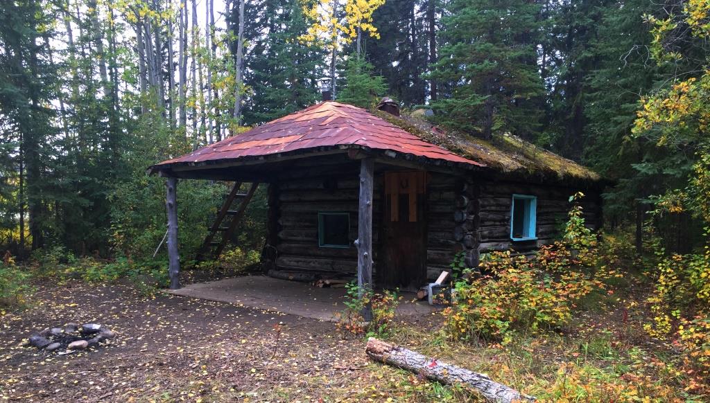
(Gord Allison photo)
Minto is an old settlement located roughly halfway between Whitehorse and Dawson City on both the Yukon River and the North Klondike Highway. When travelling north, it is a pleasant stop where the river and highway diverge and do not meet again until Dawson is reached.
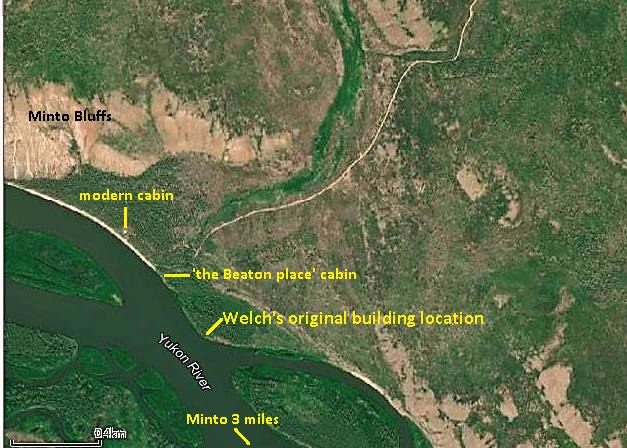
The Welch location is three miles down the Yukon River (north) from Minto and may be familiar to river travellers, but those travelling on the highway are likely not aware of it. It is commonly referred to as ‘the Beaton place’ or ‘Beaton’s Cabin’ for the last person to live there. Its modern history began with a Klondike gold rush era roadhouse and a farming operation that were started and run by Harris Welch. Before that, it was an area of use and occupation by First Nation people for an unknown period of time.
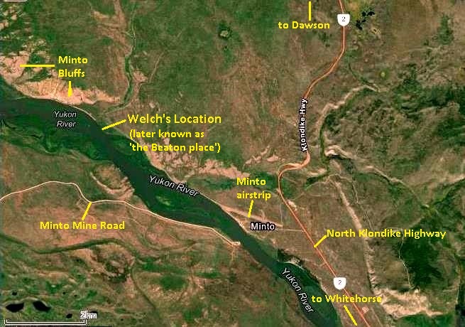
(Yukon Land Application Viewer)
Near the old cabin is a campsite that is well-used by river travellers. In the surrounding bush are remains or outlines of other buildings, while nearby a solitary grave of a later resident of the site sits on an open bench overlooking the river. A few hundred meters to the north is a modern privately-owned cabin that is visible for some distance along the river. Beyond that is the start of the Minto Bluffs that border the river for several miles.
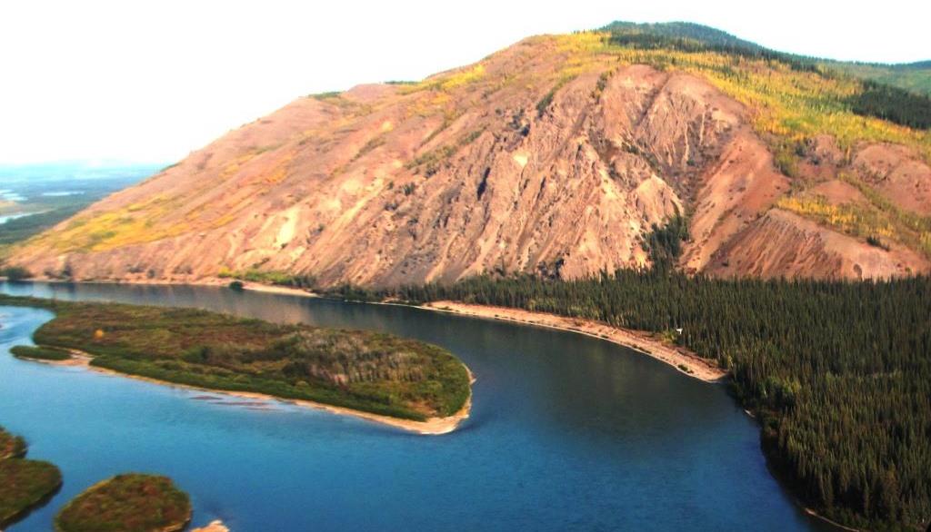
(Gord Allison photo)
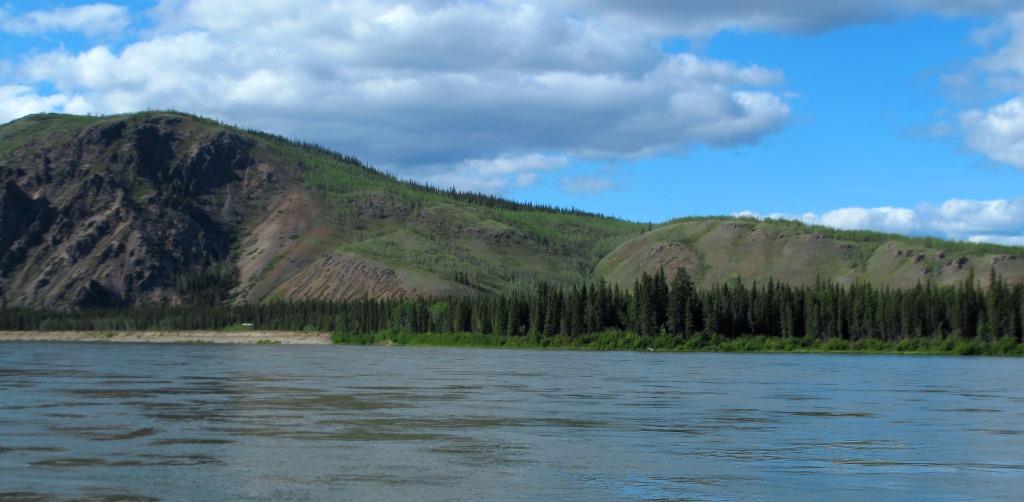
(Gord Allison photo)
Welch’s roadhouse is long gone, but the old cabin by the campsite may have been built by him and served as his base for many years of his activities there. I learned of Welch from archival research, but the only place I have seen anything written about him is in the Yukon River guidebook by Mike Rourke. It wasn’t until I found the evidence of Welch’s farm fields on the landscape that I became more interested in him and what he did there.
A Site with Many Names
This location was first documented in writing and visually in July 1883 by Lt. Frederick Schwatka of the US Army on his raft expedition down the Yukon River. Shortly after passing by the mouth of a small creek that he named Von Wilczek for an Austrian arctic explorer, he came upon a deserted First Nation village on the same (east) side of the river. It consisted of a log house about 18 feet by 30 feet and a number of brush houses. The party camped nearby and a photograph was taken of the village as well as up and down the Yukon River from the riverbank. These photographs enable the approximate location of the village to be determined.
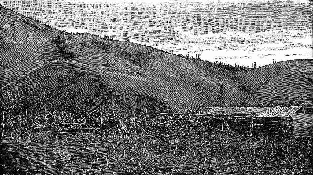
(Schwatka, A Summer in Alaska, 1893, p. 197)
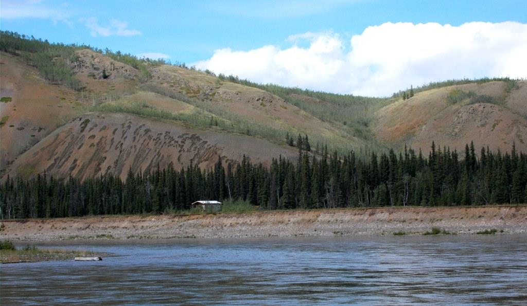
(Gord Allison photo)
Schwatka was told the site was called Kitl-ah’-gon by his Tlingit guide, and was said to mean ‘the place between high hills’. According to a 1994 report on the archaeology and history of the Minto area, the site also has two Tutchone names, Eh tzu hutslat and Haanayan, the latter meaning ‘place where people come together’.
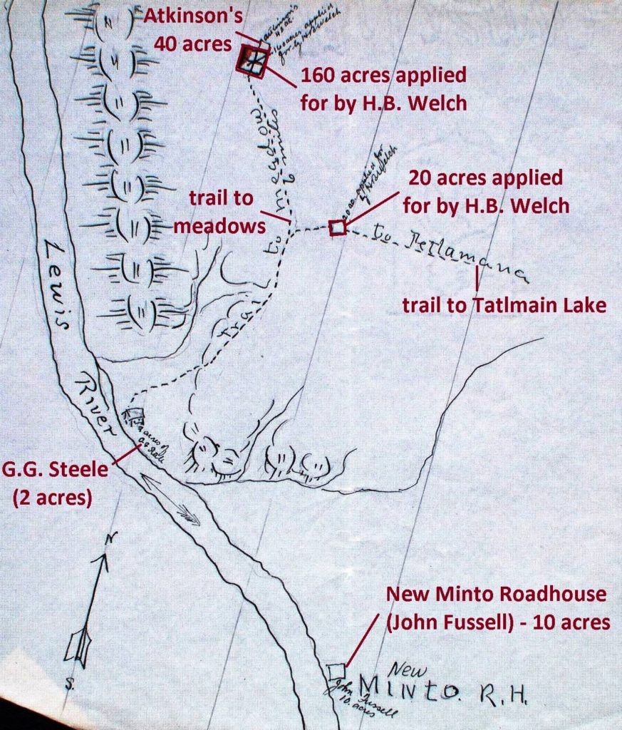
This site was used by First Nation people for a number of reasons, including as a meeting place for trading with the Tlingits from coastal Alaska. A trail to Tatlmain Lake, an important fishing lake about 30 miles to the east, led from this point on the river. It was also the location of an important river eddy used for catching salmon.
The site’s non-First Nation history started around the time of the Klondike gold rush, when Harris Welch built a small roadhouse to serve people travelling overland in the winter between Dawson City and Whitehorse. It was known as the Hay Cache roadhouse, and this name appears to have been applied to the general location for a time. Over the years it took on other names related to two people who later lived there, one of them being Finley Beaton. The Yukon Government Historic Sites unit calls the site ‘Old Tom’s Cabin’ and Mike Rourke’s guidebook refers to it as ‘Thom’s Location’, both for Ernest Thoms.
Harris Benjamin Welch
Harris Benjamin Welch was born in Ohio in 1853, the eldest of eight children in a farming family, and turned out to be a big man for the times at about six feet tall. He was a teenager when the family moved west to South Dakota, and by 1888 he was married with a daughter and the three of them moved to California. Welch was at first a carpenter, but then became a primary school and grammar teacher and was sometimes referred to as Professor Welch. His handwriting and written language attest to this type of training and background.
In 1898, the 45-year old Welch left his wife and daughter in California and joined the Klondike gold rush. In a letter he wrote almost 30 years later, in 1927, Welch said that he “joined the stampede for Dawson and the gold diggings and landed there in the spring of ’99 [but] most everything of value was taken” (meaning gold mining property). He then “decided to try farming and went up the Yukon River [from Dawson] a considerable distance where I found some land and meadows”. This place was near Minto, 191 river miles from Dawson and 248 river miles from Whitehorse.
In a land application Welch made in February 1903, he stated that he had been living at the site for four years. A petition by area residents supporting his application said that they had known Welch to reside there since the fall of 1899. These pieces of information establish that he settled at that location sometime in 1899.
Welch had probably travelled up the river from Dawson on a steamboat, bringing with him an outfit of basic food staples, hand tools, rifle, tent and living gear to get him started. Once he chose this site, he may have flagged down a steamboat occasionally and made a trip to Fort Selkirk, where there was a store, or even to Dawson to get more supplies and perhaps some building materials. He would have had to locate and clear an area, build a cabin, and lay in enough provisions and firewood to get through the first winter.
Welch had neighbors a few miles in each direction at other roadhouses along the river that he might have shared and exchanged with as needed during the winter. He would have made some trips on foot to Fort Selkirk for supplies and might also have been able to bring some in on small stage lines that were operating on the river trail. He could order things by mail with the Canadian Development Company that started freight and mail service during his first winter, and he could send telegrams (at a cost) on the telegraph line that had become operational that fall. It was not until his fourth winter (1902-03) that the Overland Trail was built through his area, enabling him to have more reliable service for mail and supplies that could be brought in on the winter stages.
During Welch’s first winter in 1899-1900, one of the most cold-blooded murder events in Yukon history occurred in his neighborhood. Eleven miles up the river (south) from his place, three innocent men were ambushed and killed on Christmas Day 1899 by George O’Brien and an accomplice, who may have been a fourth victim. These two men had come from Dawson on the river trail and stopped at other area roadhouses in the days prior. They would have passed by Welch’s, but it is not known if they stopped at his place or if he encountered them in any way. (see link to related article at end)
In early 1900 a young woman who was part of a group travelling on foot along the Yukon River winter trail to Dawson kept a diary of her trip. She recorded that on February 19, they stopped for the night at the Hay Cash (Cache) after walking for a few hours north from Minto (this would have been what is now known as Old Minto, located on the opposite side of the river and about two miles upstream of present-day Minto). She described the roadhouse as “a cabin, 12 foot square, and an old man keeps it”.
In November 1901 Welch was in Fort Selkirk and registered as a guest at the Seattle Hotel there, giving his residence as “Hay Cache, Y.Ter.”. This confirms that he was living at the site of the ‘Hay Cash’ roadhouse described in Myrtle Ryan’s diary, and that he was undoubtedly the ‘old man’ (at 47 years old) who was operating it. It further suggests that ‘Hay Cache’ may not only have been the name for the roadhouse, but also for the location, at least for a time.
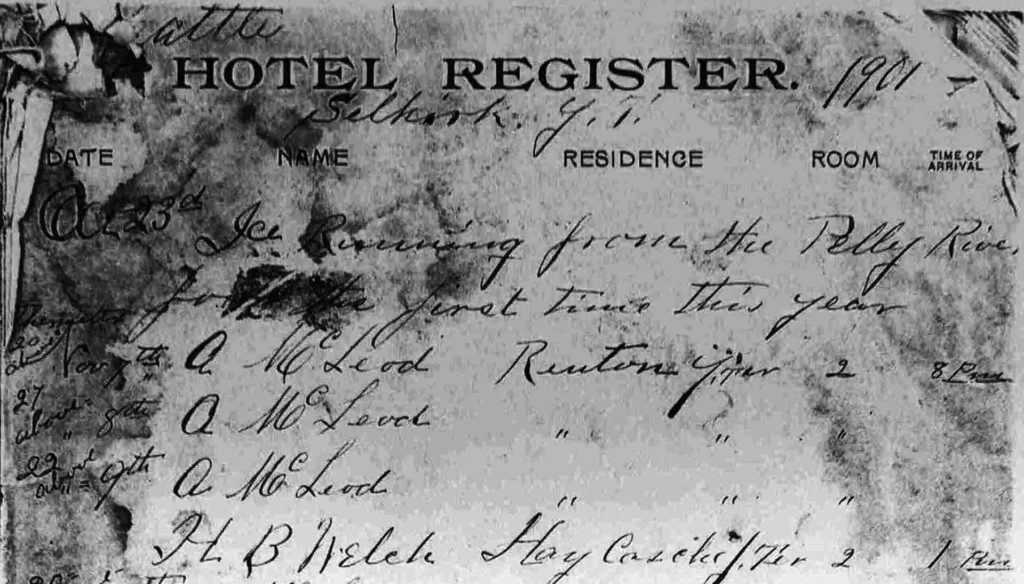
(Yukon Archives, Seattle Hotel, Acc. #80/95 – page has been cropped)
The 1901 Canada census showed Welch (listed as Walsh) as living on the right limit of the Lewes River six miles below Minto. This means on the east side of the Yukon River, which had been called the Lewes, and six miles downriver (north) of Old Minto, a description that fits for the Hay Cache site. He was also shown as having two horses there.
Immediately below Welch’s name in the 1901 census and living in the same area was that of a 25-year old man from Oregon named George Steele. Steele may have established himself there to access the trail to Tatlmain Lake to catch fish for commercial sale in Dawson, an activity carried out by a number of people during and following the gold rush. Despite being each other’s only close neighbor in a sparsely populated landscape, Steele and Welch would later have a dispute over land because of a monetary relationship they entered into.
In the fall of 1902, the Dawson-Whitehorse Overland Trail was built through the area where Welch and Steele were living. This ended the need for people to travel on the ice of the Yukon River, and instead allowed them to travel faster and safer and in relative comfort in horse-drawn sleighs and wheeled stages. It also meant an end for most of the small roadhouses, including the Hay Cache, that had served winter travellers on the river trail.
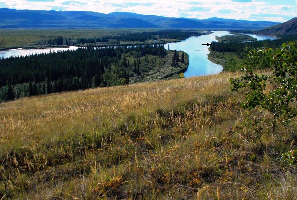
(Gord Allison photo)
Welch’s Land Dispute
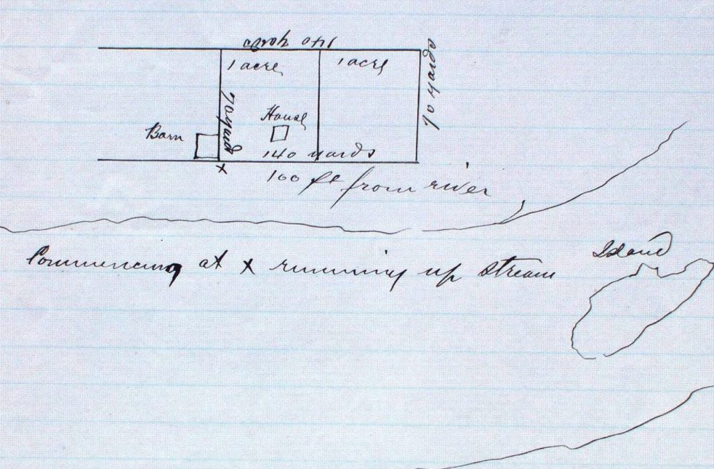
Harris Welch had been working since 1899 to develop his farm and the buildings, and in 1902, evidently short of money, he granted a chattel mortgage on his house to George Steele. The agreement was that Welch could continue to live in the house until such time as Steele were to sell it, but that Welch would have the first right of purchase if he could match the price. At that time, neither Welch nor Steele had applied for tenure to any land in the area.
(Yukon Land Application Viewer)
Sometime after that, Welch changed the mortgage to a bill of sale, later saying that he did not think that Steele would also have an interest in owning the land on which the house stood. Welch said that he had entered into this arrangement “in one of my worst moments”.
The dispute began in early February 1903, when they both applied to the government for land containing the house and barn Welch had built. Welch attached a letter saying that “I have put in much time and expense here and am still in debt for work done building. It is my only home”.
It didn’t take long for the river community from Minto to Fort Selkirk to learn about this, likely facilitated by the telegraph line that ran along the river. Very quickly a petition arose in favor of Welch and was signed by 11 area residents, including notable people such as the farmer William Swinehart, merchants in Fort Selkirk, roadhouse operators, and the steamboat captain John Fussell.
The petition contained the following statements: “We … have known Mr. H.B. Welch since the fall of 1899 and know that he has been a continuous resident [there]”; “He … has been cutting wood, clearing land, making hay and fishing … and in different ways trying to earn an honest living. We know him to be an honest, temperate and law-abiding citizen”; “We believe that he has become involved in debt through failure to sell his products (chiefly wood) and has been unable thereby to protect his buildings and improvements … by making application for a few acres of land”; and “We believe that he is liable to lose the labors of the past 3½ years … and we hereby petition … that our friend and neighbor Mr. H.B. Welch be given the first privilege of applying for said lands …”.
The government acknowledged that Welch had built both the house and barn, but decreed that the land in question should be divided. Steele would be granted the portion with the building he held a bill of sale on and Welch the part with the barn. Both applicants, however, said they “want all or none”, until the government added the threat that if they did not apply to purchase their respective parcels of land within three months, the buildings would be confiscated by the Crown. This was agreed to by the two parties.
Steele applied to purchase his two-acre parcel fairly quickly and had it approved and paid for by early July. He staked out his land, putting the dividing line between the two parcels along one side of Welch’s barn. Perhaps this gave Steele the last laugh, enabling him to have control of the entire 80 feet between his building and the property line. Steele disappears from the records after this, although his ownership of his two-acre parcel remained for several years. It is not known if he remained a neighbor of Welch’s for long, and if so what their relationship was following the land dispute.
(Yukon Archives, GOV 1633, File 6562)
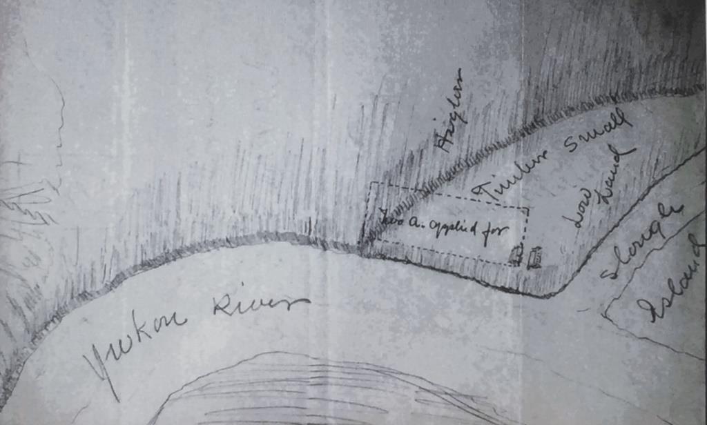
Welch appealed to the Commissioner of the Yukon, even though he had accepted the decision that he and Steele each be granted a two-acre parcel with a building on it. The Commissioner expressed some empathy for his arguments, but also admonished him: “the whole cause of grievances lies in the fact that you did not do your work in a business-like way … [and] you would not be left at the mercy of everyone who chooses to take advantage of your work”. Welch wrote back that he was satisfied with that response and applied for his two acres of land in August 1903, which he was granted that same month.
(Yukon Archives, GOV 1630, File 4738)
Welch’s Endeavors
Harris Welch had scouted out the country north of Minto and realized its potential to provide him with a farming future. In a letter to the Commissioner of the Yukon in June 1903, he wrote: “I have had all along great faith in this country’s adaptability to the growth of such products as rye, oats, [etc.] … and have had my eye on this piece of country in particular as the best I have seen …”. He was by then in the process of applying for two land parcels, which were in addition to his two acres adjacent to Steele’s. It could be that the experience with Steele spurred him on to apply for the land he had found before someone else did.
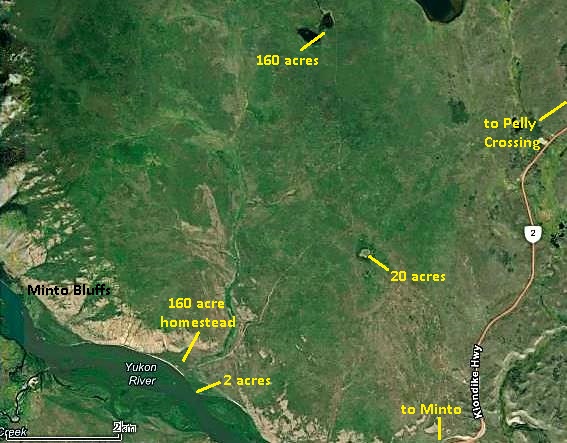
One application was made in late April for 20 acres of meadow land along the Tatlmain Lake trail about three miles inland, to the northeast of his residence on the river. It was approved not long after and Welch had the land paid for in early 1905.
He next applied in June 1903 for 160 acres of meadows and small trees about three miles further north than his 20-acre application, and thereby about six miles by trail from his place at the river. It was located beside a 40-acre application filed earlier by William Atkinson, a fellow farmer and Welch’s neighbor about eight miles downriver (northwest). Welch’s application was soon approved and he paid it off by August 1906 after some hounding by the government.
(Yukon Archives, GOV 1634, File 7799)
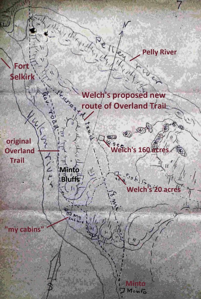
At this same time in 1903, Welch wrote to the Commissioner suggesting an 18-mile alternate route for the Overland Trail in the Minto area to avoid some rough country on the original route that was posing problems. His letter included a well-drawn map that showed the proposed route passing by his 20-acre and 160-acre land parcels. There was undoubtedly some self-interest to this proposal, as it would provide him with good access to his land, but it also made enough sense that it later became the new route of the Overland Trail.
(Yukon Archives, GOV 1630, File 4738)
In March 1909, after Yukon homesteading regulations were in effect, Welch applied for a 160-acre homestead along the Yukon River in the area of his two-acre parcel. His sketch map for the application does not mesh real well with the situation on the ground and no accurate mapping or surveying was done to plot it with any precision. His homestead was granted in July 1909.

(Yukon Archives, GOV 1645, File 24551)
Of interest on the sketch map accompanying Welch’s homestead application is the location of his residence outside (north of) the two-acre parcel he had been granted in 1903 and had presumably lived on for some time. This new residence appears to be in the proximity of the old cabin (‘the Beaton place’) beside the campsite used by river travellers. The cabin has a metal roof made from flattened metal fuel cans and the logs appear to have been treated with copper sulphate, two things that extend the life of a log building. These improvements may have been done sometime later, but nevertheless it could be that this existing cabin was built by Welch, and if so would be well over 100 years old in 2021.
Welch’s homestead application was the fourth and last piece of land he applied for in the area to the north of Minto. They were spread out from the Yukon River to meadows six miles away by trail. These distances would have added significantly to the work involved in operating his farming venture.
(Yukon Land Application Viewer)
By 1908 Welch had taken on a partner named Robert Lothrop, who referred to him as Professor Welch. During the winter of 1908-09, Lothrop’s teenaged nephew Percy Wright, who was soon to become the stepson of George Grenier, one of the founders of Pelly Farm, also stayed with Welch and Lothrop. There is no information about the nature and duration of this partnership, but by 1911 Lothrop was running the roadhouse up the Yukon River (south) at Yukon Crossing and attempting his own farming there.
It appears that for a few winters Welch took employment operating the Minto roadhouse, three miles from his home, for the White Pass & Yukon Route mail and freight service. In early 1912 he was enquiring of the government about getting firewood for “my roadhouse”, likely the one at Minto that he may have been running that winter of 1911-12. In late 1912 a list of all the White Pass roadhouse operators for the 1912-13 winter had his name attached to Minto. He was also shown to be associated with the roadhouse in 1915-16, along with another roadhouse operator of note, Anne Morrison. (see related link to Anne Morrison story at end)
In the summer of 1913 Welch made a trip to Dawson, where the newspaper there interviewed “the energetic Yukon farmer from Minto”. He claimed to have 80 acres of land cleared and seeded with potatoes, had acquired 1,000 acres for grazing land, and planned to raise reindeer, goats and sheep at his place. There is no record of him acquiring 1,000 acres of land, and the work required to plant, weed, harvest and haul 80 acres worth of potatoes could only have been done with considerable assistance. The records and physical evidence show that Welch was a hard worker, but the newspaper article may have focussed less on facts than on Welch’s dreams and ambitions, many of which did not come to fruition.
In May 1917 a Whitehorse newspaper article reported on a number of the Yukon’s farmers and their plans and preparations for the upcoming growing season. The article said that Welch “has 100 acres at Minto, where he has had remarkable success in raising potatoes. Just what he intends to do this season is not known here”. What the newspaper also did not know was that the previous October, Welch had left his home near Minto for good.
Welch After the Yukon
On November 2, 1916, Harris Welch arrived at the Port of Blaine, Washington for admission to the United States. The record showed that he had last been in the United States in 1898 and that he had become a Canadian citizen. It also showed that he was going to Los Angeles to see his wife Ada. He had likely not seen her and their daughter Edna for 18 years, as there is no record of them making a trip to the Yukon to visit him.
How the reunion with his family went, if it happened, is not known. What is known is that he did not stay there, as the 1920 United States census had 67-year old Harris living in a Seattle rooming house and working as a janitor in an office building. The census showed Ada and 30-year old Edna, a bank clerk, to be living together in a rented house in Los Angeles. As with Harris, Ada was listed as married, even though they were living two states apart from each other.
In 1918 the Canadian federal lands department began enquiring if Welch had met his homestead obligations by residing on it and cultivating the land. After their letters went undelivered or unanswered, they requested information and an inspection report from their land agent in Fort Selkirk. In August 1920 the agent replied that Welch had resided on the homestead until he left the Yukon in 1916, and his address was unknown. The agent also gave an accounting of Welch’s developments, an impressive list that would have satisfied the requirements for the homestead:
- two cabins adjoining each other of 18’x20’ each
- one cabin for hired help of 18’x20’
- two barns 25’x30’
- a hog house, hen house, blacksmith shop, two implement sheds, a well house, a large roothouse, fences, etc.
- at least 50 acres cleared and cultivated
Behind the standing cabin near the river, there is an imprint in the ground of a building about 80 feet long and built into a bank. This may have been the ‘large roothouse’ for the storage of Welch’s potatoes and perhaps also a stable for his horses as a source of heat to keep the potatoes from freezing.
In February 1927, just when he was turning 74 years old, Welch was still living in Seattle and sent a typewritten letter to the federal government in Ottawa. He said that he “lived [near Minto] until 1916 when the war stagnated everything and especially my farming proposition”. He mentioned his parcels of land, “much of which, through hard work single handed, was placed under cultivation”. He said that he “sold out some of my chattels and came outside to await a better opportunity. It may be now is my opportunity. I did not sell the land” and “now after 10 years I have a desire to go back there”.
Welch outlined how his former place and the country around it would be perfect to try raising reindeer. He was sure he could get some investors and thought that the Canadian government should grant him certain land rights and other assistance to support the project. The letter gives the impression of an old man nostalgic about his past life and perhaps wishing he had never left the Yukon.
The government responded a couple of weeks later with due sincerity and responses to the information Welch requested. It also confirmed their records as showing that he had paid the full purchase price for the 160-acre, 20-acre, and two-acre land parcels, and that his homestead had been cancelled. This did not mean that he owned the purchased parcels, but he could do so if he had them legally surveyed. No further correspondence was contained in the file and his land parcels were never surveyed.
Two and a half years later, on September 13, 1929, Harris Welch was working on a ranch in Sumner, Washington as a berry picker when he died of heart failure at age 76. He was cremated and his ashes buried there. It is not known if he ever reunited with any of his Welch family from South Dakota after he returned to the US, but they obviously learned of his death because a small headstone was placed for him at the Mount Hope Cemetery in Watertown, where many members of his family are buried.
Thoms and Beaton
What happened at Welch’s site below Minto after he left the Yukon is not clear. By at least 1928, a man named Ernest Thoms, who came from Minnesota to the Yukon with the gold rush, was living in the Minto area. He had been involved in mining in the Dawson area and then in 1911 and 1912, and perhaps other years, ran a roadhouse at the mouth of the Indian River. At some point he settled at Welch’s location, and possibly into Welch’s house.
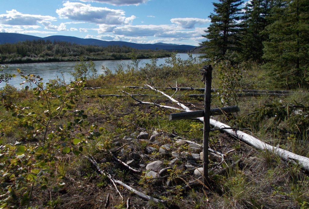
Thoms was elderly when he came to reside in the Minto area, perhaps his choice of places to retire. He told Corporal G.I. Cameron, in charge of the Fort Selkirk RCMP detachment, that he expected to die there and wanted to be buried on the bench a couple of hundred yards behind (north of) his cabin. In early September 1942, 84-year old Thoms died in his cabin of an apparent heart attack and Cameron buried him as he had requested. The solitary unmarked grave with a makeshift wooden cross overlooks the Yukon River there.
(Gord Allison photo)
Finley Beaton, a Nova Scotian, came to the Yukon with the gold rush when he was 26 and by 1901 was a woodcutter for the steamboats about 20 miles downriver (north) of Fort Selkirk. He also had a homestead in that area for a few years. Records show that by at least 1922 he had moved upriver (south) to the Minto area.
That year Beaton applied for a lease of 20 acres of land within Welch’s cancelled homestead area, but excluded the two-acre parcels granted previously to Welch and Steele in 1903. Those parcels must have still had some legal standing even though Welch and probably Steele had left the area. The following year, in October 1923, he wrote to the government to cancel his lease.
Beaton was living in the settlement of Minto in 1942 when Ernest Thoms died at the site on the river, and probably moved there after that. After living there for a number of years, Finley Beaton left the Yukon in about 1950 for British Columbia, where he had family living, and died in Abbotsford in 1960 at the age of 88. (see link to related article at end)
Finding Welch’s Fields
As I learned more about the history of the site below Minto, it became apparent that Harris Welch did a lot of work there in putting up buildings, clearing land, and growing crops, particularly potatoes. What was not clear was exactly where all these activities took place.
According to the 1920 accounting of his developments, there were about a dozen buildings attributed to him. There is presently only the old cabin remaining at the site, along with the visible remains of another, ground impressions from at least two more, and a couple of hundred meters upriver (south) there are two holes in the ground that mark Welch’s original dwelling/roadhouse and barn.
The lack of remaining buildings and evidence of them at Welch’s site may be because they were part of the ‘chattels’ he said he sold when he left the Yukon. If they were simply abandoned, log buildings in the Yukon bush that were still solid were usually viewed as a resource. They often were disassembled, moved and reconstructed elsewhere or were cut up to salvage the logs for building or for firewood. This was particularly so where the logs were easily transportable away from the site, which was the case at Welch’s.
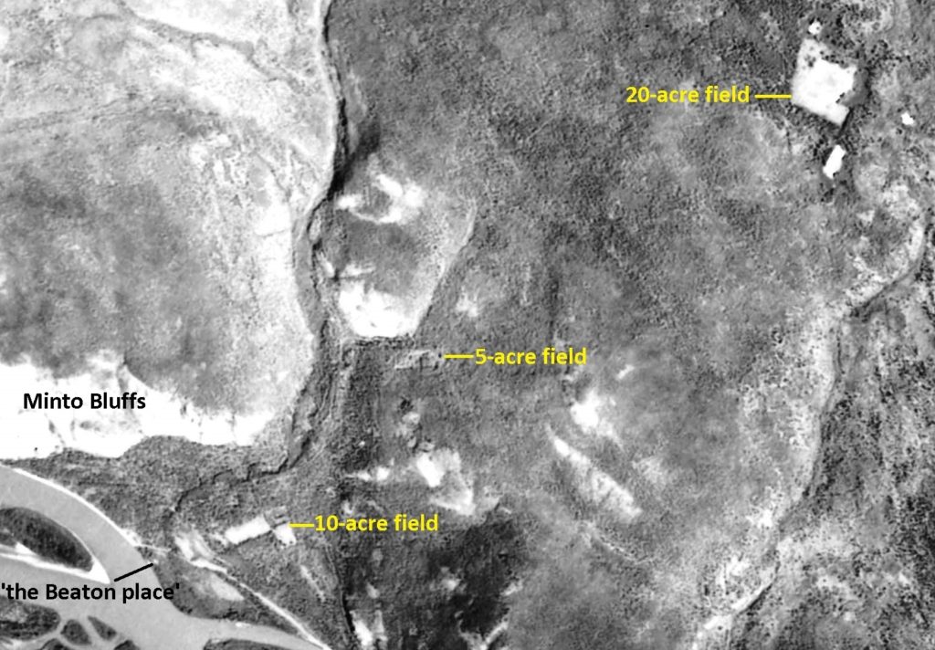
By the time Welch left the Yukon in 1916, he had purchased 182 acres of land and was trying to prove up a 160-acre homestead. He claimed to have had 80 acres under cultivation, but where these were was not stated. When I looked closely at aerial imagery with this in mind, three probable fields became quite obvious. They were visible as patches of different vegetation with straight edges, almost always the evidence of human influence on the landscape.
These patches are the most evident on a 1953 aerial photo of the area. One of them is L-shaped and about ten acres in size on a bench above the river, and would likely have been contained within Welch’s 160-acre homestead. A second patch is about five acres and along an access road about a mile from the river, and would not have been situated on any of Welch’s land. The third patch is about 20 acres and at the location of his 20-acre parcel about three miles from the river. These patches total 35 acres, so if Welch’s claim of having 80 acres under cultivation is true, there must be more that is no longer as easily detectable.
(National Air Photo Library, A13628, #7)
These patches are also still visible on modern imagery, primarily because the 1995 Minto forest fire that swept through this area burned around them but not through them. It might have been expected that the fields, which contained a good measure of spruce, albeit younger, would have burned over as well.
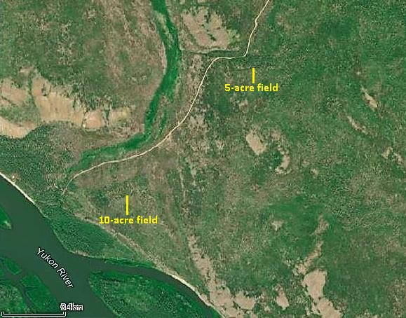
(Yukon Land Application Viewer)
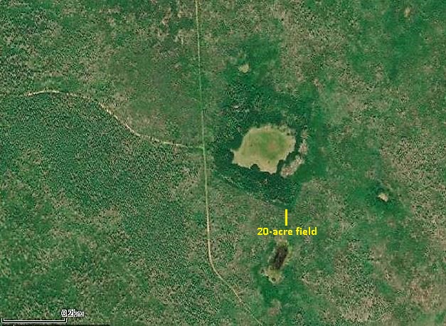
(Yukon Land Application Viewer)
In the fall of 2021 Ron Chambers and I walked to the 10-acre field, which required going over considerable fire-killed deadfall and through thick aspen regeneration. A straight line of green spruce marked the edge of the field, which contains a relatively open stand of young to medium-aged spruce with little undergrowth. It appears that this post-agriculture regrowth did not burn even though the fire around it had enough intensity to burn through the crowns of the surrounding spruce trees.
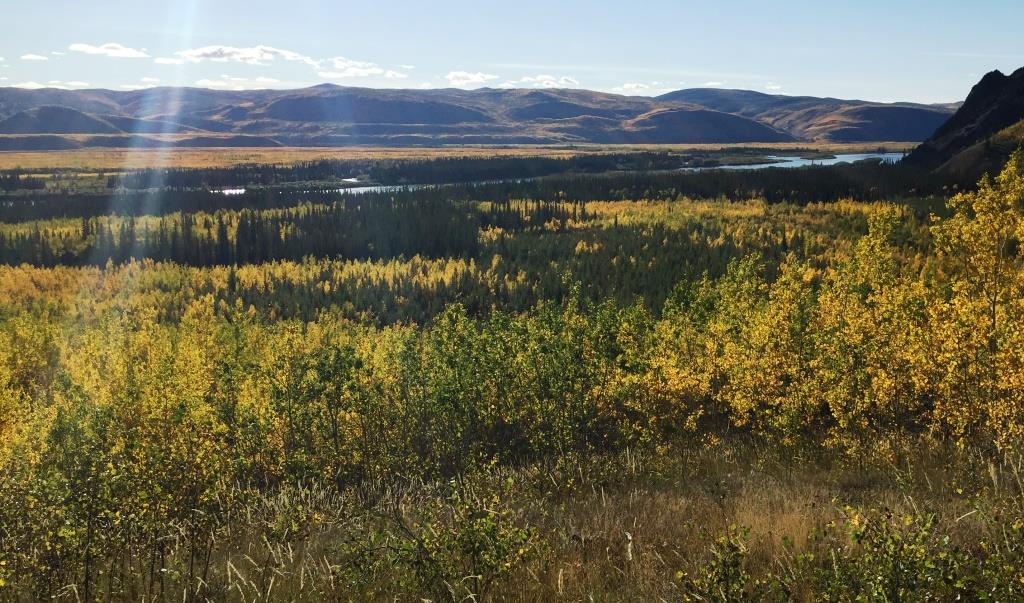
(Gord Allison photo)
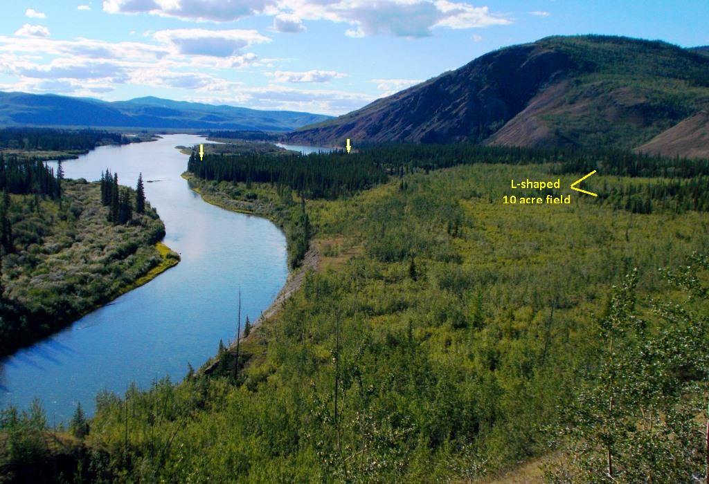
(Gord Allison photo)
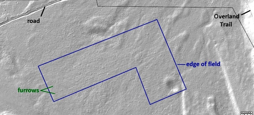
The idea that these patches of unburned vegetation were old farm fields was strengthened with the use of LiDAR coverage (Light Detection And Ranging) for the area. LiDAR laser scanning technology shows the earth’s surface as if there is no vegetation, allowing anomalies in the surface such as holes in the ground, old roads, and other ground disturbances to be easily seen that otherwise would be obscured by vegetation.
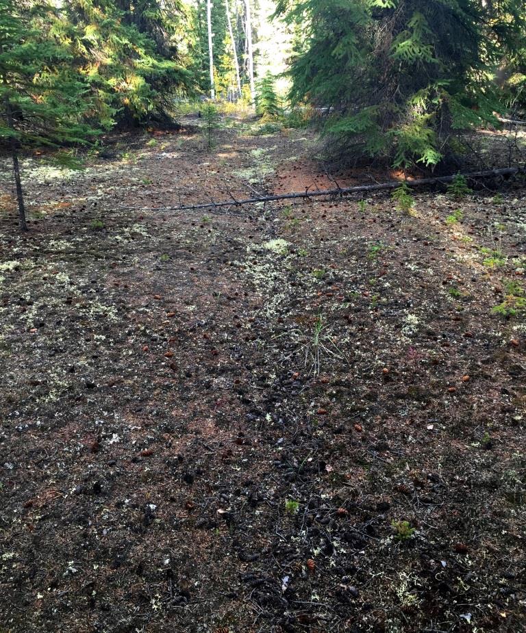
The LiDAR showed parallel lines on the ground surface in the 10-acre field and in some of the 5-acre field that has coverage. The trip to the 10-acre field revealed shallow, straight-line depressions in the ground surface that are old furrows from cultivation.
(Yukon Government LiDAR Collection)
(Gord Allison photo)
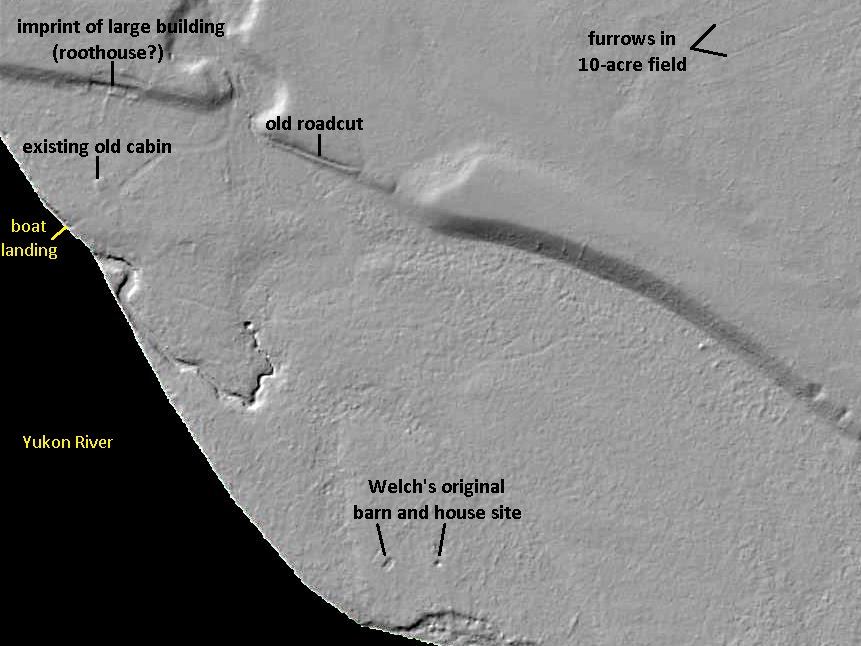
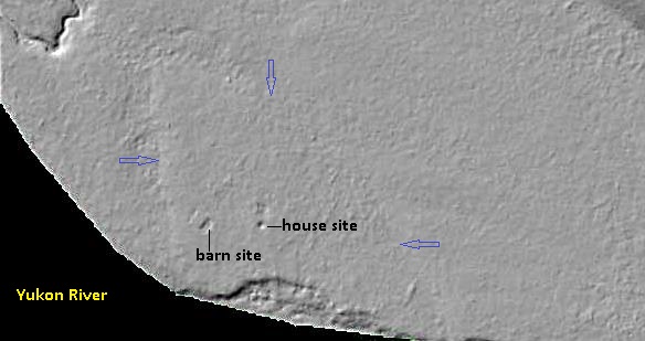
In addition to showing Welch’s fields and the furrows in them, the LiDAR revealed other features in the area, including the site of his original buildings. The barn and house that Welch and Steele came to own and occupy on their respective two-acre parcels are identified by holes in the ground. These would have been cellars, a common feature under old buildings for cold storage during the summer months. In the thick undergrowth at the site the holes could not be seen until very close to them. They are about 80 feet apart, just as described in the documents detailing the Welch and Steele land dispute.
(Yukon Government LiDAR Collection)
Surrounding the site of the original buildings is another anomaly in the ground surface revealed by the LiDAR. It is an area bounded by noticeable and relatively straight lines on three sides and the river on the fourth side. The surface inside this area appears somewhat different than that on the outside of it. It would be a reasonable supposition that Welch fenced off this area to keep his horses in while he lived there, and that the ground surface was altered by a few years of human and horse activity.
(Yukon Government LiDAR Collection)
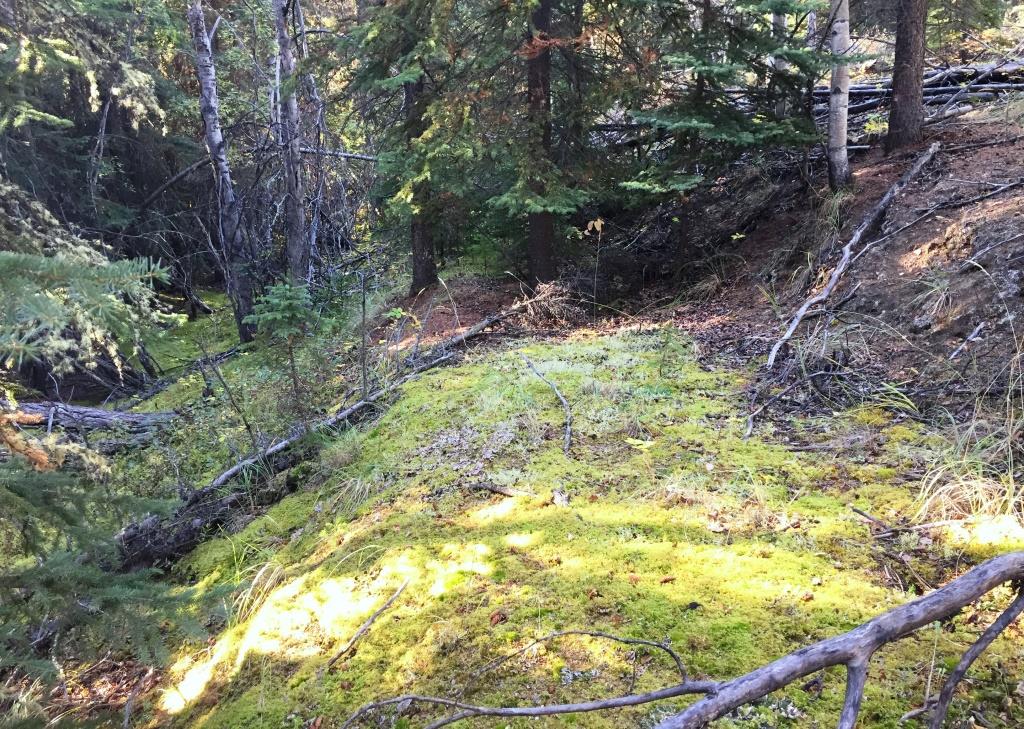
The LiDAR also showed a roadcut angling up from the river flat to the bench that the 10-acre field is located on. This road was likely built by Welch to enable him to access his fields with a horse and wagon for hauling his potatoes to his place at the river.
(Gord Allison photo)
The Scene Today
Today, Yukon River travellers passing by the area of Harris Welch’s endeavors, and the subsequent home of Ernest Thoms and Finley Beaton, would not see any indication of it. All that can be seen from the river is the modern cabin about 300 yards to the north in a clearing on the higher bank of the river. This cabin is situated on a 15-acre piece of private property.
Next to it, on the south side, is a 20.5-acre parcel of Selkirk First Nation settlement land that surrounds, but does not include, the standing cabin and nearby historical remnants. Other settlement land in the area takes in Welch’s 20-acre parcel and his 5-acre field that was not located on any land he had purchased. The site of Welch’s original buildings and most of his 10-acre field are not located on settlement land.
It is a great feature of the Yukon that historical evidence as large as farm fields such as Welch’s that were abandoned more than 100 years ago can still be found undisturbed on the landscape. Yukon River travellers can enjoy the camping area and the old cabin near the site where Harris Welch first established a roadhouse and then a farming operation. Few will know of this history, but it can be discovered by those who seek it.
Link to related article: The Christmas Day Murders
Link to related article: The Anne Morrison Story: A Prairie Family’s Yukon Life
Link to related article: Finley Beaton, Yukon River Woodcutter
Fascinating!! Great research as usual Gord. Unbelievable how persistent and hard-working these early settlers were. Very few today could compete. Incredibly interesting that a war, a world away from the Yukon, had such a pivotal impact on Welsh’s livelihood.
Thanks for your scholarly work on this important history.
Thanks very much, Derek. Yes, a lot of those guys were pretty tough, and as you say persistent in trying to scratch out a livelihood.
Fascinating. How hard he must have worked. It certainly appears that he would have known my grandmother, Anne Morrison, during her time at Minto.
Thank you for the sharing this detailed look at one of the Yukon’s old places. When tramping about here and there I frequently come across old earth works and outlines of what were once buildings of some sort. I like to sit and feel the energy of the place and wonder what trials and tribulations they are remnants of. Usually those wonderings go unanswered except for my twisting ghostly feelings. Today you have given wonderful flesh to one of those places, yet for me to visit.
Thank you for this nice comment, Matt. I’m sure a lot of people can identify with those feelings you describe. They are what got me started researching these places, to put some meat on the bones as you say. You played a part in this story by educating me about LIDAR, and I appreciate that.
Maybe you have already discovered this resource. But if not it is a great tool to explore the north with. ArcticDEM from the University of Minnesota. https://www.pgc.umn.edu/data/arcticdem/
Thank you for this, Al. I will have a look and see what it might have that could be useful for what I do.